

Honolulu Safer Streets Initiative Targets Oʻahu’s Highest-Crash Corridors
The City and County of Honolulu’s Complete Streets Office has launched the Honolulu Safer Streets Initiative, a planning effort focused on improving traffic safety along seven of Oʻahu’s highest-crash corridors. The initiative will identify potential roadway changes that can reduce serious and fatal crashes and make some of the busiest corridors in urban Honolulu safer for all users.
The initiative focuses on South King Street, Beretania Street, Young Street, Wilder Avenue, Piʻikoi Street, Kapiʻolani Boulevard, and Kāheka Street. Although these corridors represent only a small portion of Oʻahu’s roadway network, they account for a disproportionate share of serious-injury and fatal crashes. They also play an important role in Honolulu’s transportation network, connecting residential neighborhoods with schools, employment centers, commercial areas, transit routes, and other major destinations.
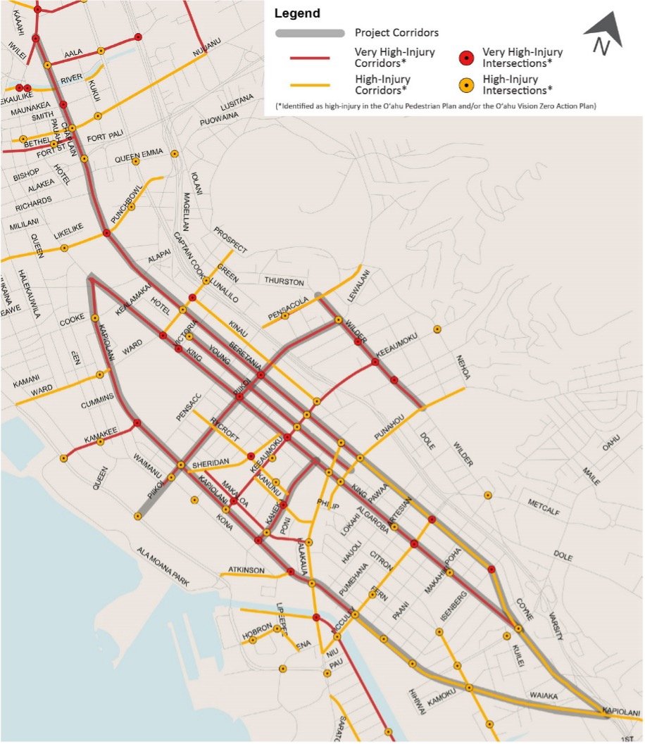
The seven corridors were identified through crash data analysis conducted as part of the Oʻahu Vision Zero Action Plan and Oʻahu Pedestrian Plan. Both plans emphasize directing safety investments to locations where crashes are concentrated, with particular attention to the safety of people walking and bicycling. The Oʻahu Vision Zero Action Plan looks at serious-injury and fatal crashes across all modes, as well as bicycle and pedestrian crashes of all severities. The Oʻahu Pedestrian Plan takes a closer look at pedestrian crash patterns and identifies locations where people walking face a higher risk of being involved in a crash.
The initiative is funded through the Federal Highway Administration’s Safe Streets and Roads for All (SS4A) program, a competitive federal grant program focused on preventing roadway deaths and serious injuries. The funding will allow the City to study these corridors closely and develop projects that can move forward into design and construction.
For each corridor, the planning process will examine crash patterns, existing conditions, and how people use the street today. Potential improvements may address a range of safety concerns, including pedestrian crossings, intersection design, vehicle speeds, bicycle facilities, transit access, and conflicts between different modes of travel.
The initiative will also look for near-term opportunities to make safety improvements as streets are repaved. Working with the City’s Department of Facility Maintenance (DFM), the City can use planned repaving projects as opportunities to update roadway striping, add flexible delineators, and install new and improved signage. These “quick-build” improvements can be implemented more easily while longer-term projects requiring additional design and funding are developed.
Community input is an important part of the process. People who use these streets everyday have first-hand experience with how they function, including locations that may feel difficult or unsafe to navigate. In August, the City hosted a community meeting in Makiki to hear feedback on the Wilder Avenue and upper Piʻikoi Street corridors. All materials from the meeting, along with more information about the Honolulu Safer Streets Initiative, are available on the City’s Urban Core Complete Streets webpage. The City plans to host its next community meeting this fall, focusing on the Beretania Street, South King Street, and Young Street corridors. The public can also provide input throughout the planning process through a variety of outreach opportunities, including the project’s interactive webmap, where people can pinpoint locations of concern and share their improvement ideas.
The Honolulu Safer Streets Initiative began in late 2025 and is expected to continue through 2027. The planning process will identify specific, actionable safety projects that can move forward into future design, funding, and construction, helping advance Honolulu’s Vision Zero and Complete Streets goals.